The Marshall fire destroyed 1,024 homes and damaged 166, worth a total of more than half a billion dollars. The fire spread very quickly over the course of just a few hours on December 30th 2021. The tragic loss of lives and homes for the people of the Marshall fire area in the middle of winter left many in the U.S. wondering what could have caused such an unusual event. The fire was driven by several abnormal characteristics including strong winds, late season drought and high temperatures, although investigators are still unsure what initially started the blaze.
What Does the ClimateCheck Data Tell Us?
Our ClimateCheck data shows us that homes in the Marshall fire area have a high risk for fire, though not extreme. 71.3% of homes damaged or destroyed in the Marshall fire had a ClimateCheck 2050 fire risk rating of “High”, and 28.3% had a score of “Significant”. Only 0.3% were rated “Low” risk.

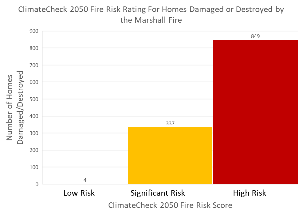
No homes were rated “Very High” or “Extreme” fire risk; this indicates that areas of consistently “High” risk can be put in severe danger by fire risk under the right conditions, even in December. The fire started on the edge of a wildland area at a time of very high winds, which is likely a significant factor for how it spread so quickly and dangerously. The intersection of wild spaces and buildings in the wildland-urban interface can be especially dangerous for residential housing. As shown in the graph below, the Marshal Fire area had higher risk than some other Colorado communities, including nearby Boulder and Denver.
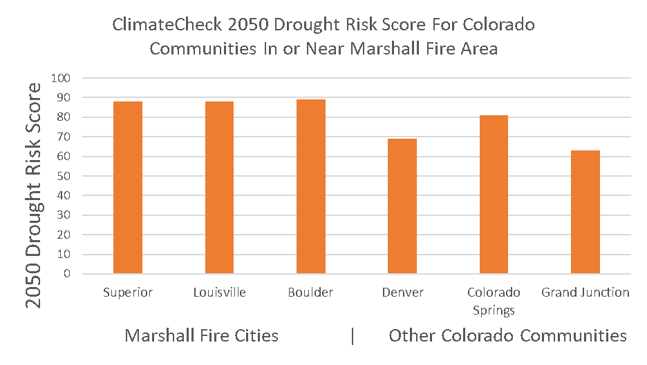
The ClimateCheck data highlights the connection between drought, heat, and fire risk. Droughts and sustained high temperatures may increase the severity of fires when they occur. When hot, dry, and windy weather combines with flammable dried out vegetation, it increases the probability of extreme wildfires. Communities in the Marshall Fire area have “Extreme” drought risk scores from ClimateCheck. This pattern, combined with the record-breaking temperatures in the region between June and December of this year, the Marshall area was in prime condition for sparks to spread. The graph below shows drought risks in the communities surrounding Marshall.

How Does Marshall’s Fire Risk Compare to the Surrounding Area?
ClimateCheck data shows that there were very few houses within the burn area with low risk. The Marshall burn area in general had a “High” average fire risk score of 51.4. Other nearby cities had much lower average risk, such as Boulder (31.0 – “Significant”) and Denver (16.4 – “Low”).


In addition, newly built homes in the Marshall area carry higher risk on average than nearby areas. The following graph shows the Conditional Risk to Potential Structures (CRPS), a US Forest Service metric, for the recently build structures in the Marshall Fire area.


Interpreting risk of fire depends on balancing the general benefits of a particular property with a person’s tolerance for fire risk. Unfortunately, living in an area with only “Significant” or “High” risk does not mean that extreme fires will not affect that area, only that the likelihood of them starting and spreading is lower than in “Very High” or “Extreme” risk areas.
Conclusion
One takeaway from the destructive event of the Marshall fire is that the combination of drought and fire risk can be deadly, especially with extreme and unusual weather patterns exacerbated by climate change. How these risks combine with local weather and vegetation patterns can vary widely from property to property. Tools like the ClimateCheck risk report can help homeowners get a better sense of how their risk compares to properties in the same town and region.