Fire Risk Ratings and the McKinney Fire Perimeter
On Friday, July 29, 2022 the McKinney fire broke out at approximately 2:15 pm in Northern California. Firefighters responded to a report of a wildfire starting in the Klamath National Forest near the Klamath River, as shown in Figure 1. The fight to keep the fire contained required a Type 1 Incident classification with as many as 2,404 personnel. Four individuals tragically lost their lives in the McKinney fire as it tore through over 60,000 acres. As of August 13, the fire reached 90 percent containment. The cause is still undetermined and under investigation.
The ClimateCheck Fire Risk Rating uses metrics such as the Fire Weather Index (FWI) to shed light onto how the McKinney fire spread and the risk factors within and surrounding the fire area. This article presents data on the fire perimeter, the risk rating within this area, and the number, location, and age of houses and other structures.

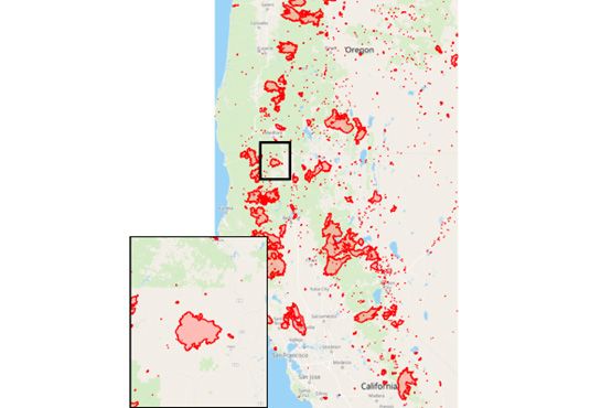
Figure 1: Location of the McKinney Wildfire in Northern California.
Wildfire Risk Rating - The Fire Weather Index (FWI)
The ClimateCheck Wildfire Risk Rating is based on data representing extreme fire weather and probabilistic fire behavior characteristics. We calculate the Fire Weather Index (FWI), a daily wildfire danger rating system metric that accounts for the effects of moisture content and wind on the amount of fuel available for combustion and how quickly a fire might spread. FWI is a measure of potential fire intensity—or energy available to be released—and a good indicator of overall fire danger. Input data to the FWI include temperature, precipitation, relative humidity and wind speed from 20 Coupled Model Intercomparison Project Global Climate Models (GCMs) downscaled to 6km spatial resolution.
We estimate two parameters from FWI distributions per GCM:
- Frequency: the annual counts of extremely dangerous fire weather days.
- Magnitude: the intensity of danger for extreme fire weather days.
This is a measure of how often extremely dangerous fire weather occurs and how much more extreme it will be. This method looks at changes in the upper tail end of daily FWI values that exceed the historical extreme magnitude. Extreme is defined as FWI values exceeding the 99th percentile. Figure 2 shows how the magnitude and frequency of extreme FWI days changes over the next few decades for the area within the McKinney Wildfire perimeter.
We use the FWI to model fires because the majority of severe (high consequence) wildfires occur on days with high FWI values (Hawkins, Abatzoglou, Li, & Rupp, 2022; Wang et al., 2022). FWI is also more reliable than other approaches to modeling climate risk for wildfires. While increases in the FWI due to anthropogenic climate change have been observed over the past several decades (Jain et al., 2017), climate risk models that explicitly parameterize land cover and land use change over projected time are susceptible to high degrees of uncertainty (Syphard, Sheehan, Rustigian-Romsos, & Ferschweiler, 2018). FWI is therefore the preferred metric for modeling wildfire severity and how climate change will impact wildfire risk.

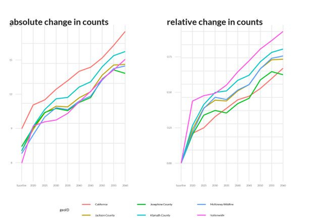
Figure 2: FWI trends over time in the McKinney wildfire perimeter.
Since extreme FWI estimates are at too coarse a spatial resolution for property-level risk assessment, we utilize recently released, 30m resolution 2020 US Forest Service (USFS) wildfire risk data products known as Risk to Potential Structures (RPS), which is the likely damage if a house were present and a fire occurred. Figure 3 shows RPS around the McKinney Wildfire perimeter. This wildfire severity product represents:
- Burn Probability: the chance of a wildfire starting (frequency)
- Flame Length Exceedance Probability: likelihood that flame length exceeds a certain height (intensity)
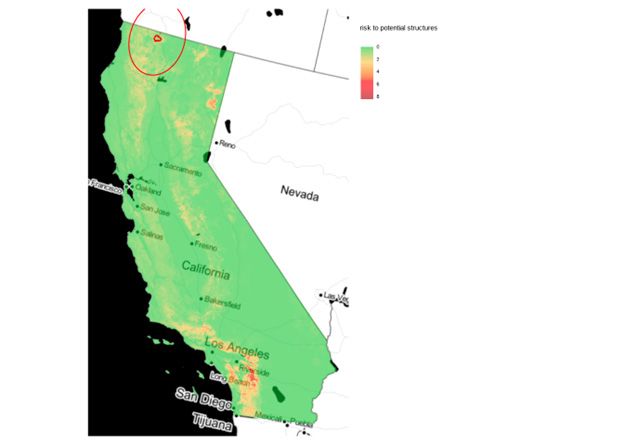
Figure 3: USFS Risk to Potential Structures around the McKinney Wildfire
We combine the change in extreme FWI exceedances with these static USFS data to represent how wildfire frequency, intensity, and severity will shift over future time. We also factor into account the larger environmental context surrounding a specific property and the amount and type of land cover, urbanicity, and agricultural activity. Figure 4 shows the ClimateCheck Wildfire Risk Rating around the McKinney Wildfire perimeter. In summary, this rating method excels at estimating:
- Property-level differentiation in wildfire risk
- Frequency, intensity, and severity of wildfire events
- Wildfire risk over the 21st century

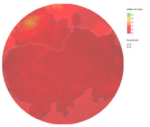
Figure 4: ClimateCheck Wildfire Risk Rating around the McKinney Wildfire
Wildfire risk is 0.18 percent higher within the McKinney Wildfire perimeter (average risk rating = 82.55) than for the neighboring area (average risk rating = 82.4). Table 1 provides comparison statistics for the McKinney Wildfire perimeter and the nearby surrounding area.

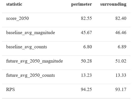
Table 1: Comparison statistics for the McKinney Wildfire perimeter and the nearby surrounding area.
Exposed Structures in the McKinney Fire Perimeter
Wildfires typically occur in wildland vegetation areas with very few people and structures. The Wildland-Urban Interface (WUI) describes areas where settlement intersperses with undeveloped wildland vegetation. The WUI has been increasing in geographic extent, number of structures, and population over the past several decades (Radeloff et al., 2018). This trend means more human ignitions and a greater difficulty in protecting life and property. Figure 5 displays buildings around the McKinney Wildfire perimeter. There are approximately 165 buildings inside the fire perimeter and about 284 buildings within one mile of the perimeter.
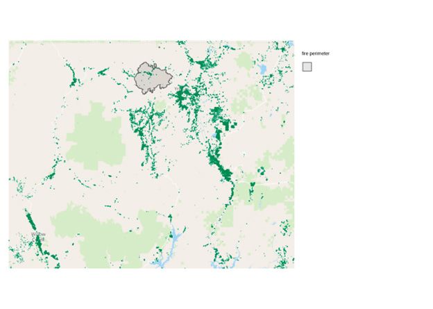
Figure 5: Building locations in the McKinney Wildfire vicinity.
Many of these buildings were constructed in recent years. The number of new builds constructed since 2000 in nearby Census Tracts was estimated at 1.813610^{4}, which is about 13.9 percent of total structures. Figure 6 shows these construction trends over time while Figure 7 presents the proportion of new builds, both for Census Tracts around the McKinney Wildfire.
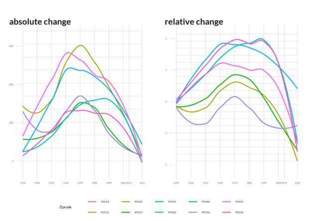
Figure 6: Number of houses built over time in zip codes around the McKinney Wildfire.
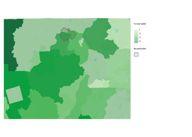
Figure 7: Percentage of structures built since 2000 in zip codes surrounding the McKinney Wildfire.
For further information on sources, reference these studies:
Hawkins, L. R., Abatzoglou, J. T., Li, S., & Rupp, D. E. (2022). Anthropogenic Influence on Recent Severe Autumn Fire Weather in the West Coast of the United States. Geophysical Research Letters, 49(4), e2021GL095496. https://doi.org/10.1029/2021GL095496
Jain, P., Wang, X., Flannigan, M. D., Jain, P., Wang, X., & Flannigan, M. D. (2017). Trend analysis of fire season length and extreme fire weather in North America between 1979 and 2015. International Journal of Wildland Fire, 26(12), 1009–1020. https://doi.org/10.1071/WF17008
Radeloff, V. C., Helmers, D. P., Kramer, H. A., Mockrin, M. H., Alexandre, P. M., Bar-Massada, A., … Stewart, S. I. (2018). Rapid growth of the US wildland-urban interface raises wildfire risk. Proceedings of the National Academy of Sciences, 115(13), 3314–3319. https://doi.org/10.1073/pnas.1718850115
Syphard, A. D., Sheehan, T., Rustigian-Romsos, H., & Ferschweiler, K. (2018). Mapping future fire probability under climate change: Does vegetation matter? PLOS ONE, 13(8), e0201680. https://doi.org/10.1371/journal.pone.0201680
Wang, B., Spessa, A. C., Feng, P., Hou, X., Yue, C., Luo, J.-J., … Yu, Q. (2022). Extreme fire weather is the major driver of severe bushfires in southeast Australia. Science Bulletin, 67(6), 655–664. https://doi.org/10.1016/j.scib.2021.10.001