Which states are the riskiest in terms of wildfire danger posed to homes?
When assessing fire risk for a property, it’s most helpful to look at the risk in the area surrounding that property. But to understand your level of fire risk, it helps to have context, like: How does the risk for my home compare to others in my state? And how does my state compare to other states?
Comparing risk for areas as large as states, though, can be complex. Let’s pick California as an example, since California is an intuitive choice for having one of the highest fire risks.
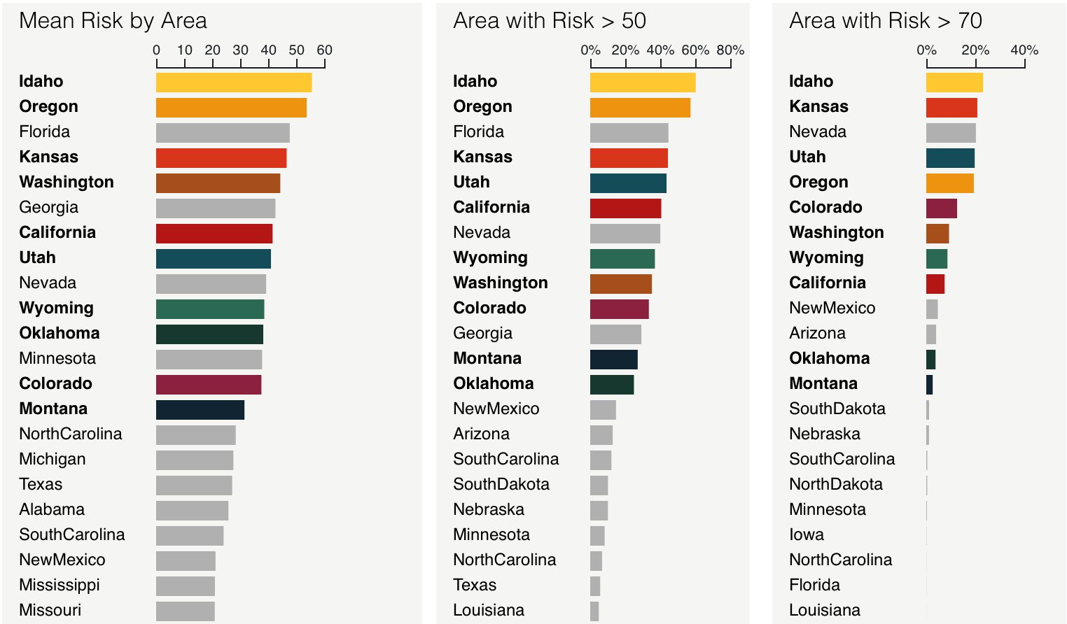
Key metrics for assessing wildfire risk are:
- Average ClimateCheck fire risk rating in each state (by land area)
- Fraction of area in the state with a risk rating over 50
- Fraction of area in the state with a risk rating over 70

California is near the top of these lists, but it’s behind other states that have a lot of low-population area. For example, we see that about 41% of California has a risk over 50 and 7% has a risk over 70, representing a lot of area with high risk. Idaho has even more land at high risk, with 60% of area having a risk over 50 and 23% having a risk over 70.
Since we’re focused on risks to homes and property it’s important to focus on how wildfire affects populated areas. Lots of the land that burns from wildfire is in forests largely uninhabited by humans. Though nearby wildfires pose many hazards, especially from smoke, we’re considering just the number of buildings that are likely to actually burn.
So, what risk does the typical person in California experience? Because ClimateCheck is concerned with rating risks for properties, we use building locations from Microsoft to look at the fire risk of all the buildings in each state.
Key metrics for assessing risks to property are:
- 75th percentile of risk (25% of the buildings in the state have higher risk than this number)
- Fraction of buildings in the state with risk > 50
- Fraction of buildings in the state with risk > 70

Utah ranks #1 or #2 for all three of these metrics. Unlike in California, much of Utah’s population is centered in one metro area, and the combination of high fire risk around Salt Lake City with populations expanding outward from the city core into the wildland-urban interface means that fire risk affects a significant fraction of buildings in the state.
There are many other ways we could rank fire risk. For example, if we ranked states by the total number of buildings with a fire risk over 70, California would rank 4th. These buildings make up a small percentage of structures in the state, but in terms of amount of money spent or number of people evacuated, they represent a significant risk.
In order to capture both the amount of risk present in a state, along with the typical risk for a given home or property in a state, we’ll create a composite fire risk ranking, which is an average of the state’s ranking for the six categories above.

(50 states, minus Alaska and Hawaii, plus Washington DC, which ranks last for fire risk.)
Here’s a plot of the composite fire risk ranking, based on the average of the six categories above. Utah, Idaho, and Kansas tie for the highest risk, with Wyoming, Oregon, Colorado, Montana, Washington, Oklahoma, and California rounding out the top ten.
These summaries hide information about the extremes in each state, and many places in each of these states have high fire risk; it’s important to understand the risk surrounding your specific property. But looking at different ways of comparing states can illuminate different challenges that states face as we all deal with increasing wildfire risk.