Rising sea levels, in isolation, are primarily based on two factors: ice sheet and glacier meltwater and the thermal expansion of ocean seawater. Climate change has caused global sea levels to rise by exacerbating these two factors, but the relative pace of this change has not been evenly spread across the globe. Forceful geologic factors like subsidence have a major influence on relative sea level rise, the factor which ultimately determines how much danger rising oceans pose to your home and property.
- Relative Sea Level Change: how the height of the ocean relates to the height of land in a particular location.
- Absolute Sea Level Change: The height of the surface of the ocean, as measured from the center of the earth, not relative to land movement.
The subsidence of land in many places along the American coasts has increased the inundation of flood waters; flooding is made worse by absolute sea levels that have steadily increased in recent years due to climate change.

Human activities are responsible for many subsidence issues, especially because of the impacts of excessive groundwater extraction to support cities and agriculture. Some estimates indicate that up to 80 percent of subsidence in the U.S. is caused by the exploitation of underground water stores. The remainder is mainly due to geologic factors.
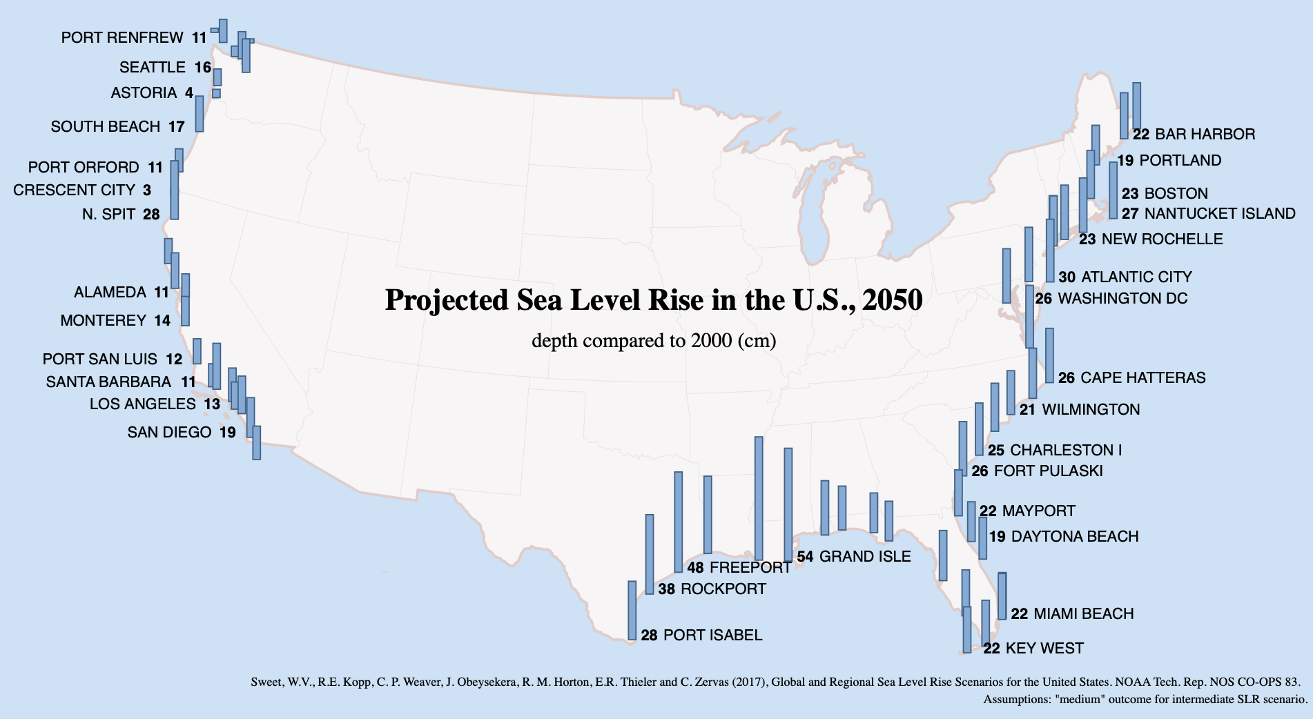
Geographic differences between the East and West Coasts have also caused stark differences in the impact of relative sea level rise. Climate-induced sea and land movements have risen relative sea levels by as much as 8 inches in the Mid Atlantic and Gulf Coasts. This sea level rise has caused significant danger to coastal real estate and infrastructure. By contrast, coastal land elevation in some locations of the Pacific Northwest and Alaska outpaces the rate of rising water, often putting them out of danger from worsened coastal flooding due to rising absolute sea levels.
Geologic Factors of Subsidence
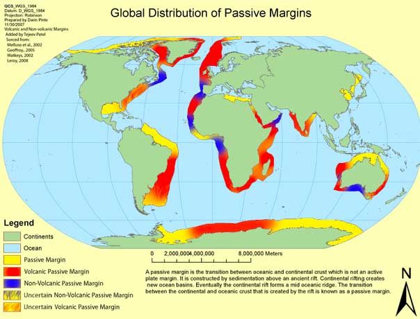
The East and West Coasts of America are very different geologically, which results in different rates of subsidence, or the gradual sinking of an area of land. The biggest fundamental difference between the two is that they have different types of continental margins.

The crust of the earth is broken into sections called plates. There are two types of plates, oceanic (basalt rock) and continental (mostly granite rock). Continental plates, including the North American Plate which covers almost all of America, are always in a slow rate of motion of approximately one to ten centimeters a year. In the long term, the continental plates reshape the surface of the planet in major ways.
The direction a continent is headed, or its leading edge, determines whether or not a continental margin is active or passive. This difference determines the subsidence rates of the East and West Coasts.
West Coast
- Active Margin
- Where the edge of the continental plate is moving towards an oceanic plate.
- Prone to dramatic geologic activity such as earthquakes, volcanoes, and the formation of mountains.
East Coast & Gulf Coast
- Passive Margin
- Found along coastlines where there is no collision with other plates.
- Weathering and erosion processes are prominent, and tectonic activity is at low levels.
- Active margins like the West Coast lead to more geologic activity, more rock building, and often a rise in the levels of coastal lands. This effect helps decrease the dangers of rising seas within those areas. The opposite is true of passive margins, where powerful erosion processes are carrying away land and volcanic activity is not replacing the lost rock.
Groundwater Exploitation and Mitigation
Subsidence has increased in some areas in recent years, often because of human alteration of natural water systems. Subsidence rates in some areas like the gulf coast are approximately twice of long-term geologic rates. The removal of subsurface water, often through excessive extraction, is the major cause of this rapid subsidence.
When too much water is pumped from groundwater systems, it causes the subsoil to compact. This can result in the reduction of the size and total number of “pore spaces” in the soil that are responsible for holding water, therefore permanently reducing the storage capacity of aquifer systems. Famously, land levels in the San Joaquin Valley in the center of agricultural California have dropped as much as 28 feet (8.5 meters) since the last century due to excessive groundwater removal.

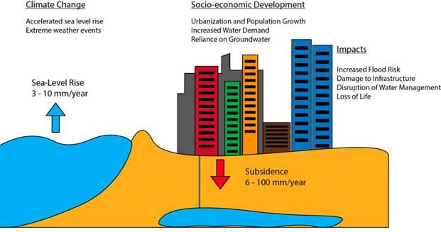
Many large and rapidly urbanizing cities are called “sinking cities” due to the danger of their rapidly changing landscapes. The combined effects of sea level rise, hurricanes, storm surge, land subsidence and other climate-related weather effects are causing extreme danger to the vitality and safety of coastal and river cities, despite investments in infrastructure. Some cities have developed sophisticated methods of monitoring land subsidence, while others lack the resources necessary to accurately track the complex geological forces responsible for subsidence and therefore have no official records.
Venice is often the most well known of the sinking cities, because of its long-term historical connection to issues of water management. But the dangers of subsidence are being felt in major economic centers across the world such as Jakarta, Ho Chi Minh City, Bangkok, New Orleans, and Tokyo. Urbanization and increasing needs for resources in some of these locations have worsened subsidence by drawing too heavily on groundwater supplies. These critical hubs of the global economy are becoming more exposed to water-related natural disasters, and often lack the resources to invest in needed mitigation options.
Conclusion
It is important to understand how secondary geologic factors impact sea level rise, to such an extent that it alters the severity of rising waters along much of the U.S. coastline. Other factors also contribute to coastal movement along the Atlantic Coast, including groundwater withdrawal, sediment loading, and the erosion processes of the Appalachians Mountains. For this reason, localized geographic factors are a key part of understanding exactly what forces are responsible for sea level rise in your community.
Get an Instant Risk Assessment
Select...